

Get ready for a wild weekend of weather in New York City! This Saturday and Sunday, the area is expecting a mix of snow, ice, and rain. If you’ve got plans, it’s important to know what’s coming so you can stay safe and dry. With winter weather advisories in place, we’ll see everything from fluffy snowflakes to slippery ice and puddles. As we dive into this stormy weekend, let’s find out how much snow and rain to expect, and what to do to prepare for winter’s icy grip!
| Area | Precipitation Type | Expected Amount | Timing | Weather Advisory |
|---|---|---|---|---|
| NYC Area | Snow, Ice, Rain | 1-3 inches of snow, 1-2 inches of liquid equivalent | Snow Saturday, Rain Sunday | Winter Weather Advisory issued |
| Hudson Valley | Snow transitioning to rain | 3-5 inches of snow, 1-2 tenths of an inch of ice | Snow past midnight, Rain by evening | Winter Weather Advisory issued |
| South Jersey | Rain | Less than 1 inch of snow | Rain by early evening | Minimal advisory due to mild temperatures |
| Long Island | Snow transitioning to rain | 1-3 inches of snow, rain on Sunday | Snow Saturday, Rain Sunday | Winter Weather Advisory issued |
| Coastal Areas | Rain with possible thunder | 1-2 inches of liquid equivalent | Heavy rain possible Sunday afternoon | Low-lying area flooding possible |
Weekend Weather Overview: Snow, Ice, and Rain
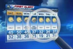
This weekend, NYC is bracing for a storm that will bring a mix of snow, ice, and rain. On Saturday morning, you can expect dry roads, which will be perfect for any errands you have to run. However, as the day progresses, temperatures will drop and snow will start falling around lunchtime. By Saturday evening, rain will begin to replace the snow, especially in the city, while the Hudson Valley will continue to see snow until late at night.
The storm is significant because it marks the last in a series of East Coast storms, and it could bring heavy snow and ice. Winter weather advisories are in effect from Central Jersey to the Hudson Valley. This means that people should stay informed about the weather and be prepared for changing conditions. The mix of precipitation is expected to create slippery roads and difficult travel conditions throughout the weekend.
What to Expect: Snow Accumulation and Ice Risks
In NYC and northern New Jersey, the expected snowfall is between 1 to 3 inches, with some areas getting up to 5 inches. The Hudson Valley could see even more snow, which will lead to a beautiful winter scene but also present challenges. As the storm progresses, freezing rain could create a hazardous layer of ice on roads and sidewalks, making it important for everyone to be cautious when going outside.
The ice accumulation in the Hudson Valley is estimated to reach one to two-tenths of an inch. This can lead to heavy branches and potential power outages if the ice builds up too much. It’s crucial to be aware of these risks and prepare accordingly. Stay indoors if possible, and if you must go out, wear appropriate footwear to prevent slipping on icy surfaces.
After the Storm: Flooding and Temperature Drop
As the storm passes, Sunday will see rain taking over, turning the snow into slush by the afternoon. While this rain is needed to help with drought conditions in the area, it can lead to isolated flooding in streets and low-lying regions. It’s important for people to be aware of their surroundings and avoid flooded areas to stay safe during this messy weather.
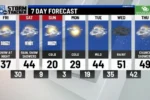
After the storm clears, a drop in temperatures will follow, with highs expected to be below freezing. This means that even though the rain might wash away the snow, the cold weather will return. So, don’t forget to grab your warm coats and parkas! The beginning of the week will bring sunny days, but the chill will remind everyone that winter is still here.
Understanding the Snow to Rain Transition
As the storm approaches NYC this weekend, understanding the transition from snow to rain is crucial for planning your activities. Initially, the area will experience snow accumulation, which is expected to start around lunchtime on Saturday. As temperatures gradually rise in the evening, this snow will begin to mix with sleet and then transition to rain, particularly in urban areas. This shift will create a wet and slippery environment, making it essential to stay updated on the changing weather conditions.
For residents in the Hudson Valley, the transition will take longer. Snowfall will continue well into the night before turning to rain. This delay means that areas further north may grapple with icy conditions for most of the weekend, leading to hazardous travel. Being aware of these changes can help you mitigate risks, such as avoiding driving during peak storm hours and ensuring you have appropriate footwear and gear if you must be outdoors.
Impact of Ice Accumulation on Infrastructure
Ice accumulation poses significant risks to infrastructure during winter storms. In the upcoming storm, areas like the Hudson Valley could see ice build-up of one to two-tenths of an inch. This seemingly small amount can lead to hazardous conditions, including heavy ice on power lines and tree branches, which may snap under the weight. Such incidents can result in power outages and damage to property, making it vital for residents to stay informed about local advisories.
Moreover, icy conditions can create dangerous travel situations. Roads may become slick, leading to accidents or delays in emergency responses. It’s important for residents to prepare for potential power outages by having emergency kits ready, including flashlights and non-perishable food. Additionally, understanding the risks of ice can help individuals take precautions, such as avoiding unnecessary travel during the storm and being mindful of their surroundings.
Weekend Weather Precautions and Recommendations
As the weekend storm approaches, taking appropriate precautions is essential for safety. Saturday morning will be the best time to run errands, as conditions will be dry. However, as the day progresses and snow begins to accumulate, it’s advisable to stay indoors if possible. If you must go out, ensure you wear appropriate footwear to prevent slips on icy surfaces, and keep an eye on local weather updates for any changes in conditions.
On Sunday, the rain will likely turn Saturday’s snow into slush, creating messy conditions. It’s recommended to wear rain boots and be cautious of flooding in low-lying areas. While the rain is needed to alleviate drought conditions, it can also lead to localized flooding. Avoid driving through flooded streets, and be prepared for potential road closures. Planning your weekend around the weather will help you stay safe while navigating the storm.
Post-Storm Weather Outlook
Once the storm passes, the forecast indicates a shift toward clear, sunny days, which is a welcome relief after a weekend of severe weather. However, this sunny weather comes with a trade-off: temperatures are expected to plummet, with highs dropping below freezing. It’s essential to prepare for these colder conditions, which could feel even harsher due to wind chill, making it crucial to dress warmly when heading outdoors.

The return of sunshine may help dry up some of the lingering slush, but the reality of winter is still upon us. Residents should be ready to face several days of cold temperatures, reminding us that winter is far from over. Keeping warm with layers and staying informed about further weather changes will be key as we transition from this stormy weekend to a chilly start to the upcoming week.
Frequently Asked Questions
What types of weather can we expect this weekend in NYC?
This weekend in NYC, expect a mix of **snow, ice, and rain**. Saturday will start with snow, then change to rain later, making it a **messy Sunday**.
Why is it important to do errands early on Saturday?
It’s smart to do errands early on Saturday because the **roads will be dry** in the morning. By afternoon, snow and ice will make driving **dangerous**.
What happens when freezing rain falls?
**Freezing rain** falls as liquid and freezes when it touches cold surfaces. This makes roads and trees **icy**, which can cause accidents and power outages.
How much snow can we expect in different areas?
In NYC, we may get **1 to 3 inches** of snow, while areas farther north could see **3 to 5 inches**. South Jersey will have less than an inch.
What should you wear on a rainy Sunday?
On a rainy Sunday, it’s best to wear **rain boots** to keep your feet dry. The rain will turn Saturday’s snow into **slush**, which can be messy!
Will there be any flooding this weekend?
Yes, the rain could cause **isolated flooding** in streets and low-lying areas. Be careful if you’re out and about!
What should we expect after the storm passes?
After the storm, we can look forward to **sunny days**, but it will be very cold. Expect temperatures below freezing, so you’ll need your **warm clothes**!
Summary
The content discusses an impending winter storm affecting the NYC area, bringing a mix of snow, ice, and rain this weekend. It highlights that Saturday morning will be the best time for errands, as conditions worsen by afternoon with snow starting around lunchtime. The transition to rain will occur in NYC by evening, while the Hudson Valley will see snow until later. Expected snow totals range from 1 to 5 inches, with potential ice accumulation causing hazardous conditions. Sunday will mainly bring rain, alleviating drought concerns but risking localized flooding. A cold snap will follow, leading to below-freezing temperatures.
