

Welcome to your Tuesday Evening Update! As we get ready for an exciting night of winter weather, let’s dive into what’s happening outside. Snow has arrived in central Maryland, and it’s getting heavier in some areas. This update will help you understand what’s coming next, including snow accumulation and other weather alerts. Stay tuned as we explore how temperatures are dropping, roads are becoming slick, and how this winter storm is shaping up. Get your mittens and hot cocoa ready, because winter is here, and there’s much to learn about it!
| Time/Date | Weather Conditions | Temperatures | Weather Alerts | Snowfall Forecast (inches) | Upcoming Weather |
|---|---|---|---|---|---|
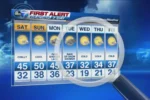
| Tuesday Evening | Heavy snow in Southern Maryland, lighter snow in Northern Maryland and Southern Pennsylvania. | Below freezing, icy untreated roads expected. | Winter Storm Warnings and Advisories in effect. | NAM: 5.9” ECMWF: 5.2” GFS: 4.8” HRRR: 3.4” | Transition to sleet and rain expected in some areas, then back to snow before midnight. |
| Wednesday Morning | Snow expected to taper off with lingering flurries. | Temperatures above freezing by morning, wet roads. | Transition from snow to rain, watch for freezing rain in some areas. | Minimal additional accumulation expected. | Dry break expected before the next system arrives. |
| Wednesday Evening | Freezing rain transitions to rain overnight. | Above freezing temperatures expected overnight. | Watch for potential freezing rain alerts. | Transitioning to rain, especially in Southern areas. | Next system expected Thursday morning. |
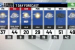
| Weekend (Saturday-Sunday) | Light snow may begin, transitioning to moderate to heavy rain. | Warm air expected, temperatures rising. | Watch for winter weather alerts for snow and rain. | Light snow in Southern Pennsylvania, rain expected for most areas. | Cold air to arrive next week with potential for more snow. |
| Next Week | Uncertain conditions, possible storms developing. | Polar air returning, colder temperatures expected. | Monitor for updates on storm potential. | Chance for snow as the week progresses. | Changes in forecast possible, stay updated. |
Understanding Winter Weather Alerts
Winter weather alerts are important notifications issued by the National Weather Service. These alerts inform people about hazardous weather conditions such as snow, sleet, or freezing rain. For instance, when a Winter Storm Warning is in effect, it means that significant snowfall is expected, which could make driving dangerous. People should pay close attention to these alerts to stay safe and prepare for any necessary changes in their plans.
Winter Weather Advisories are also issued to let people know about potentially tricky conditions. For example, if light snow is falling and making roads slippery, an advisory helps people understand to be cautious. Knowing these alerts can help families prepare. They can stock up on supplies or decide if they need to stay indoors when the weather gets bad.
What to Expect During a Snowstorm
During a snowstorm, the weather can change quickly. Typically, snow begins to fall heavily, making roads slick and difficult to navigate. It’s crucial to be aware of the temperatures, as they often drop below freezing. If roads are untreated, they can become very dangerous. Drivers should be extra careful during these times and consider staying home if possible.
As the storm progresses, you might notice changes in the type of precipitation. Sometimes, warmer air can cause snow to mix with sleet or even rain. This can lead to a messy mix of weather, making conditions even more challenging. It’s essential to stay updated on the latest forecasts and be prepared for sudden changes in the weather.
Looking Ahead: Future Weather Patterns
As we move beyond the current snowstorm, it’s important to look ahead to what weather patterns might come next. After a snowstorm, warmer temperatures can lead to rain, which can wash away any lingering snow. However, this doesn’t mean that winter is over! Another storm system could bring more snow or ice in the following days, so keeping an eye on forecasts is crucial.
Forecasters use computer models to predict future weather, but these predictions can change. Sometimes, it’s difficult to tell exactly what will happen. For example, while one model might predict snow, another might suggest only rain. This uncertainty is why weather updates are important. By staying informed, families can prepare for whatever weather may come next!
Understanding Winter Weather Alerts
Winter weather alerts are essential for keeping the public informed about hazardous conditions. The National Weather Service issues these alerts based on forecasts that predict significant snowfall, ice, or a combination of both. For residents in affected areas, understanding the types of warnings, such as Winter Storm Warnings and Winter Weather Advisories, is crucial for making safe travel and lifestyle choices during severe weather events.
In the current weather scenario, these alerts highlight the importance of preparedness. With temperatures dropping and snow accumulation expected, residents should stay updated on local advisories. By paying attention to these warnings, individuals can take proactive measures, such as avoiding travel during peak storm conditions or preparing their homes for potential impacts from winter weather.
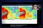
Model Comparison: NAM vs. HRRR
When it comes to predicting snowfall, model accuracy is key. The NAM (North American Mesoscale Model) and the HRRR (High-Resolution Rapid Refresh) are two commonly used weather models that forecast snowfall intensity and timing. In this instance, the NAM 3 Km model has outperformed the HRRR, providing a clearer picture of snow arrival and accumulation. Understanding the nuances between these models helps meteorologists refine their forecasts and better inform the public.
The differences between the NAM and HRRR models can significantly impact snowfall predictions. For instance, the NAM suggests a more substantial accumulation in certain areas, which can lead to differing expectations for road conditions and travel safety. By analyzing these models, forecasters can present a more accurate snowfall outlook, allowing residents to prepare adequately for the impending weather.
Forecasting the Transition to Warmer Weather
As winter storms pass, weather conditions will inevitably shift. Following the current snow event, forecasts indicate a transition to warmer temperatures. This shift is expected to bring rain, impacting previously snow-covered areas. Understanding this transition is crucial for residents, as the melting snow can lead to slick roadways and potential flooding in low-lying areas.
Looking ahead, the forecast suggests that after the snow, temperatures will rise above freezing, resulting in rainfall and the melting of accumulated snow. This change poses both benefits and challenges. While warmer temperatures can alleviate some winter woes, they can also create hazardous conditions as snow melts quickly. Residents should remain vigilant and prepared for rapidly changing conditions.
The Long-Term Weather Outlook
In weather forecasting, understanding long-term patterns is essential for planning ahead. The current forecast indicates a potential return to colder temperatures next week, hinting at the possibility of another winter storm. Monitoring these patterns not only helps residents prepare for immediate weather changes but also provides insight into how the winter season may unfold in the coming weeks.

As we transition from one weather system to another, it’s crucial to stay informed about potential storm developments. The forecast shows an active environment, with confidence levels varying regarding future storms. By keeping an eye on these long-term predictions, residents can better prepare for whatever weather the season may bring, ensuring safety and readiness.
Frequently Asked Questions
What does a Winter Storm Warning mean?
A **Winter Storm Warning** tells us that a big snowstorm is coming. It means we should be careful because there will be a lot of snow, making roads slippery and travel dangerous.
How do weather models predict snowfall?
Weather models, like the **NAM** and **HRRR**, use data to guess how much snow will fall. They compare temperatures, moisture, and wind to make their predictions, helping us prepare for storms.
What happens when warm air meets cold air during a snowstorm?
When **warm air** meets **cold air**, it can create **sleet** or **freezing rain**. This happens because the warm air melts the snow into rain before it hits the ground, making roads extra slippery.
Why do temperatures drop after a snowstorm?
Temperatures drop after a snowstorm because of the **Polar Air** moving in. This cold air makes it chilly again, which can lead to more snow or icy conditions.
What should we do during a snowstorm?
During a snowstorm, we should stay **indoors** if possible. If we must go outside, we should wear **warm clothes** and be careful on slippery roads. It’s also smart to have supplies ready at home.
What is the difference between snow and sleet?
**Snow** is frozen water that falls from the sky in soft flakes, while **sleet** is small ice pellets. Sleet occurs when rain freezes before hitting the ground, making it hard and slippery.
How can we prepare for heavy rain after a snowstorm?
To prepare for heavy rain after snow, we should check for **flood warnings** and make sure our **drainage** systems are clear. Keeping an eye on the weather helps us stay safe.
Summary
The evening update covers the anticipated snowstorm, highlighting the effective performance of the NAM 3 Km model over the HRRR model. Current conditions show temperatures below freezing, leading to slick roads as snow begins to fall across central and southern Maryland. Winter Weather Alerts remain in effect, with snow expected to continue into the night, transitioning to sleet and rain in some areas. A brief dry period is forecast for Wednesday morning, followed by freezing rain and rain later in the day. Looking ahead, another system may bring light snow and rain over the weekend, with colder temperatures expected next week.
