

Attention, snow lovers! A big winter storm is heading to Western Colorado, and it could bring multiple feet of snow! This exciting weather event comes with lots of changes, like snowfall in the mountains and rain in the valleys. With strong winds and heavy snow expected, it’s important to be careful if you’re traveling. The National Weather Service has issued special alerts for snow accumulation, wind gusts, and even avalanche risks. So grab your warm clothes and get ready to learn all about this fascinating winter storm!
| Weather Event | Location | Snowfall Expected | Wind Gusts | Advisories | Timing |
|---|---|---|---|---|---|
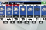
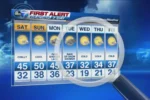
| Winter Storm | Western Colorado | 1-2 feet in high country, 6-12 inches in certain areas, 1-4 inches in valleys | 40-45 MPH | Winter Storm Watch, Winter Weather Advisory, Avalanche Watch | 6 PM Thursday to 6 PM Saturday (varies by area) – Avalanche Watch until 5 PM Saturday. |
| Valley Snowfall | Highway 50 areas (Grand Junction, Delta, Montrose) | 1-4 inches | N/A | N/A | N/A |
| High Mesa Snowfall | Grand and Battlement Mesas | Up to 1 foot | N/A | N/A | N/A |
Understanding the Winter Storm Watch
A Winter Storm Watch means that severe winter weather is possible in the area. In this case, the National Weather Service has warned of heavy snowfall in Western Colorado. They predict that high mountain areas could receive between 1 to 2 feet of snow from Thursday evening through Saturday. This watch is crucial for residents and travelers to prepare for snowy conditions that could impact daily activities and travel plans.
During a Winter Storm Watch, it’s important to stay updated on weather reports and alerts. Snowfall can create difficult driving conditions, especially in the mountains where roads may get covered quickly. If you have plans to travel, make sure to check the weather before heading out. Keeping an emergency kit in your car and ensuring your vehicle is winter-ready can help you stay safe during these storms.
Preparing for Heavy Snowfall
With the forecast predicting multiple feet of snow, preparation is key. Families should make sure they have enough food, water, and supplies in case they need to stay home for a few days. It’s also smart to prepare your home by clearing gutters and downspouts to prevent ice build-up. Having a snow shovel and salt or sand can help you manage snow and ice around your driveway and walkways.
If you live in areas prone to heavy snowfall, it’s wise to monitor your local news for updates. School closures, road conditions, and safety alerts will be announced as the storm approaches. Also, check on your neighbors, especially the elderly or those who may need help with snow removal. Working together as a community can make a big difference when heavy snow hits.
Staying Safe During Winter Storms
Safety is the top priority during winter storms. If you must travel, take precautions such as driving slowly and keeping an emergency kit in your car. This kit should include items like blankets, food, water, and a flashlight. High winds may create whiteout conditions, making it hard to see. If the weather gets too severe, it’s best to stay off the roads until conditions improve.
In addition, be cautious of avalanche risks in the mountains. An Avalanche Watch is in effect for several areas, indicating that loose snow could slide down slopes. If you enjoy skiing or snowboarding, make sure to check avalanche conditions before heading out. Staying informed and taking the necessary precautions will help you stay safe during this winter storm.
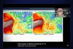
Understanding Atmospheric Rivers and Their Impact on Weather
Atmospheric rivers are crucial phenomena that transport moisture from tropical regions to higher latitudes, significantly impacting local weather patterns. This particular event, heralded as a winter storm system, is marked by the influx of moisture that can lead to heavy snowfall, especially in mountainous regions. As this moisture-laden air ascends, it cools, condensing into precipitation, which can manifest as several feet of snow in the high country of Western Colorado.
The presence of an atmospheric river in this winter storm is pivotal in predicting snowfall amounts and intensity. Meteorologists monitor these rivers closely, as they often correlate with potential weather warnings. For residents in affected areas, understanding this connection can help them prepare adequately for the impending snow and hazardous conditions that accompany strong winds and low visibility.
Safety Precautions During Severe Winter Weather
As the First Alert Weather Day unfolds, prioritizing safety becomes essential. Drivers are advised to avoid unnecessary travel, especially in regions under winter advisories and avalanche watches. Those who must venture out should equip their vehicles with winter gear, including snow tires and emergency supplies, to navigate the treacherous conditions effectively.
Moreover, outdoor enthusiasts planning to ski or hike in the backcountry should heed avalanche warnings seriously. Loose snowfall can create unstable conditions that may lead to dangerous slides. Staying informed through local weather updates and heeding advisories from authorities can significantly reduce risks during severe winter weather events.
Projected Snowfall Totals and Local Impact
According to meteorological forecasts, Western Colorado can expect substantial snowfall, with predictions ranging from 1 to 4 inches in valley regions and significantly higher amounts in the mountains. This storm could bring up to 2 feet of snow in specific high-altitude areas, posing challenges for residents and local infrastructure. Roads may become impassable, and power outages could occur due to heavy snow accumulation on trees and power lines.
Communities should prepare for disruptions by ensuring that they have adequate supplies and communication plans in place. Local authorities may also implement snow removal operations to maintain accessibility on critical routes. Understanding these projected totals helps residents gauge the severity of the situation and take proactive measures.
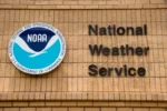
The Role of the National Weather Service in Monitoring Storms
The National Weather Service (NWS) plays a crucial role in monitoring winter storms and issuing timely alerts to keep the public informed. By utilizing advanced technology and meteorological data, the NWS can predict storm patterns, snowfall totals, and potential hazards associated with severe weather. Their warnings, such as Winter Storm Watches and Avalanche Watches, provide vital information that can help individuals make informed decisions.

In addition to issuing alerts, the NWS also provides educational resources on how to prepare for severe weather conditions. They emphasize the importance of staying updated through reliable channels and understanding weather terminology. This proactive approach not only enhances public safety but also fosters a community that is better prepared for winter weather challenges.
Frequently Asked Questions
What is a Winter Storm Watch and why is it important?
A **Winter Storm Watch** is a warning that heavy snow or ice could happen soon. It’s important because it helps people prepare for dangerous weather, like staying safe indoors or planning travel carefully.
How does snow form during winter storms?
Snow forms when **moisture** in the air freezes into ice crystals. These crystals stick together to create snowflakes. When enough snowflakes gather, they cover the ground, making everything look white and fluffy!
What should I do during a Winter Weather Advisory?
During a **Winter Weather Advisory**, it’s best to stay indoors if possible. If you must go out, wear warm clothes, drive slowly, and be careful of slippery roads!
What causes strong wind gusts during winter storms?
**Strong wind gusts** happen when cold air from storms mixes with warmer air. This can create powerful winds that can blow snow around and make driving unsafe.
What is an Avalanche Watch and how does it affect skiers?
An **Avalanche Watch** means there’s a risk of snow sliding down mountains. It’s important for skiers to be careful and avoid steep areas where avalanches might happen.
How much snow can we expect in different areas during this storm?
In the **high country**, expect up to **2 feet** of snow, while valleys might see **1-4 inches**. Areas like Montrose may get more, so check local updates!
Why does snow change to rain during winter storms?
Snow can change to **rain** when temperatures rise above freezing. This happens during the day when warm air replaces the cold, making it too warm for snow to form.
Summary
The content discusses an impending winter storm system expected to impact Western Colorado significantly. Forecasts indicate multiple feet of snow in the high country, with 1-2 feet anticipated under a Winter Storm Watch, effective from Thursday evening to Saturday evening. Valleys may experience snowfall transitioning to rain by Friday. Wind gusts of 40-45 MPH could create hazardous travel conditions. Additionally, a Winter Weather Advisory predicts 6-12 inches in certain areas, while an Avalanche Watch warns of potential risks in the backcountry. Overall, the storm poses significant weather challenges and urges caution among residents and travelers.
