

Hello, young weather watchers! Are you ready to learn about the exciting weather coming our way? In Hazard, Kentucky, we’re in for a warm day today, but there’s a twist! Mornings might feel a bit chilly, but by afternoon, the sun will bring temperatures up to the lovely upper 60s. Although we might see some rain later this week, don’t worry! We’ll also get warmer days ahead. Let’s dive into the details of what to expect in our forecast, including the chance of wintery surprises and the importance of staying updated with the weather!
| Day | Morning Temperature (°F) | Afternoon Temperature (°F) | Conditions | Night Temperature (°F) | Rain Chances | Upcoming Weather |
|---|---|---|---|---|---|---|
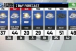
| Tuesday | Upper 20s to Low 40s | Mid to Upper 60s | Mostly Sunny | 30s to Low 40s | Slight Chance of Morning Showers | Warm weather continues into Wednesday. |
| Wednesday | Mid 40s (approx) | Upper 60s | Partly Cloudy | Near Freezing | Rain expected after 10 p.m. | Cooler temperatures on Thursday and Friday. |
| Thursday | Upper 30s to Low 40s | Low 50s | Rain tapering off by afternoon | Near Freezing | Possible brief wintry mix overnight | More rain expected Thursday evening and into Friday. |
| Friday | Low 30s | Low 50s | Cloudy/Rainy | 30s | Continued rain | Cooler temperatures continue. |
| Saturday | Low 40s (approx) | Upper 50s | Partly Sunny | 40s | Low chance of rain | Warm-up before a cold front hits. |
| Sunday | Low 40s | Low 40s | Mostly Cloudy | 40s | No significant rain expected | Cooler temperatures return. |
Understanding Today’s Weather Forecast
Today is going to be a warm day in Hazard, Kentucky! In the morning, you might need a light jacket because temperatures will be a bit chilly, starting from the upper 20s to low 40s. But don’t worry! By the afternoon, the sun will come out, and the temperatures will rise to the mid to upper 60s. Just keep an eye out for a few morning showers, which should clear up by 9 a.m. and give way to a beautiful afternoon.
As the day goes on, you can expect mostly sunny skies that will make it feel warmer. Even though it will be a nice day, remember that temperatures will drop overnight into the 30s. So, if you have any plans in the evening, make sure to dress warmly! It’s always good to check the weather before heading out, especially when temperatures can change so quickly.
What’s Coming Up This Week?
Looking ahead to Wednesday, the weather will stay warm with highs reaching the upper 60s. However, after 10 p.m., clouds will gather, and rain will start to fall overnight into Thursday. This rain will help keep the air fresh, but it will also cool down the temperatures. So, if you have any outdoor plans, try to finish them before the rain begins. It’s always smart to stay prepared for sudden weather changes!
After the rain on Thursday, temperatures will drop to the low 50s, feeling much cooler than earlier in the week. Friday will continue this cooler trend, so be sure to wear warmer clothes when you head outside. The weekend will start to warm up again before a cold front sweeps through, bringing temperatures back down to the low 40s. Weather can be unpredictable, so keep an eye on your local forecast to stay updated!
Stay Safe with Weather Alerts
Weather alerts are important to keep everyone safe! In Hazard, Kentucky, there is currently a flood warning until 10 a.m. on March 3. This means that heavy rain could cause flooding in some areas, so it’s essential to be cautious and avoid flooded roads. Staying informed about any weather warnings helps you make safe decisions, especially when severe weather is expected.
To stay updated on the latest weather alerts, consider downloading the WYMT First Alert Weather App. This free app will send you notifications about any changes in the weather for your area. You can also watch the WYMT First Alert WeatherNOW channel for up-to-date forecasts. Being prepared with the right information is key to enjoying your day and staying safe!
Understanding the Week’s Weather Patterns
The weather in Hazard, KY, this week showcases a classic transition from early winter to spring-like conditions. On Tuesday, residents can expect a chilly start, with temperatures ranging from the upper 20s to low 40s in the morning. However, as the day progresses, these temperatures will rise significantly, reaching the mid to upper 60s by afternoon. This fluctuation illustrates the unpredictable nature of spring weather, where warm afternoons can follow cold mornings.
As we move into Wednesday, the warmth continues with highs expected to hit the upper 60s. Partly cloudy skies will dominate the day, providing a pleasant backdrop for outdoor activities. However, as night falls, the forecast indicates rain starting around 10 p.m. This shift reminds us that while spring brings warmth, it also introduces rain showers, which are essential for replenishing the environment after winter.
Preparing for Rainy Days Ahead
With rain forecasted to start on Wednesday night, it’s crucial for residents to prepare for wet conditions. The rain is expected to persist overnight and into Thursday, creating potential hazards on the roads. Drivers should be mindful of reduced visibility and slippery surfaces, especially during the initial downpour. Staying updated on local weather alerts can ensure safety and assist in planning for any necessary delays in travel.
On Thursday, after the rain tapers off, temperatures will cool down into the low 50s, marking a significant drop from the previous days. This shift serves as a reminder to have appropriate clothing ready, as the weather can change rapidly. Keeping an umbrella handy and wearing layers will help residents stay comfortable during this transitional period. A brief wintry mix could also occur Thursday night, emphasizing the need for readiness.
The Impact of Cold Fronts on Local Weather
The arrival of a cold front this week will dramatically change the weather in Hazard, KY. Following the warmer temperatures and rainy days, residents can expect a noticeable drop in temperatures, particularly by Sunday when highs may only reach the low 40s. Understanding how cold fronts function is essential; they often bring abrupt changes in weather patterns, leading to cooler temperatures and increased precipitation.
As the cold front settles in, it may lead to additional weather phenomena such as wind gusts or even snow flurries in some areas. This fluctuation can affect daily life, from commuting to outdoor events. Staying informed through reliable weather sources, such as the WYMT First Alert Weather App, is crucial for adapting plans to changing conditions. Awareness of these patterns helps residents stay prepared and safe.
Tips for Staying Safe During Weather Changes
As the weather transitions from warm to cold, it’s essential to prioritize safety. Ensure that your home is equipped for potential weather changes, such as having sufficient heating and proper insulation. Additionally, keep an emergency kit with essentials, including flashlights, batteries, and non-perishable food, as rain and cold fronts can lead to power outages.

Moreover, when venturing outdoors, dress appropriately for fluctuating temperatures. Layers are key in managing comfort as the weather changes throughout the day. Always pay attention to weather alerts and advisories, especially concerning flash floods or severe storms, which can occur unexpectedly during rainy periods. Being proactive can make a significant difference in safety and comfort.
Frequently Asked Questions
What will the weather be like on Tuesday morning?
On Tuesday morning, temperatures will be **chilly**, ranging from the **upper 20s** to **low 40s**. A few **morning showers** might occur, but skies will clear by **9 a.m.**.
How warm will it get on Tuesday afternoon?
By Tuesday afternoon, temperatures will rise to the **mid to upper 60s**. It will feel much warmer and more pleasant, perfect for outdoor activities!
What happens to the temperature overnight on Tuesday?
Overnight on Tuesday, temperatures will drop into the **30s**, with some places staying in the **low 40s**. This means you might need a **sweater** if you go outside!
What should we expect for Wednesday’s weather?
On Wednesday, expect **partly cloudy** skies with highs in the **upper 60s**. However, rain will start after **10 p.m.**, so keep an umbrella handy!
Will it rain on Thursday?
Yes, rain is expected on Thursday, starting overnight and continuing into the afternoon. Temperatures will be cooler, reaching only the **low 50s**.
What is a wintry mix?
A **wintry mix** is when rain, snow, and sleet fall together. There might be a brief wintry mix on Thursday night as temperatures drop near freezing.

How can I stay updated on the weather?
You can download the **WYMT First Alert Weather App** to get the latest weather updates and alerts. It’s free and keeps you informed anytime!
Summary
The content provides a weather forecast for HAZARD, Ky., indicating a warm day on Tuesday with temperatures ranging from the upper 20s to mid-60s. Morning showers are possible, but skies should clear by 9 a.m. Overnight temperatures will drop into the 30s. Wednesday will see highs in the upper 60s with rain expected after 10 p.m., continuing into Thursday. A cooler trend follows, with highs in the low 50s and potential wintry mix overnight on Thursday. A brief warm-up is anticipated for Saturday before a cold front brings temperatures back down to the low 40s on Sunday.
