

Have you ever wondered what happens when winter decides to take a break? Well, that’s exactly what’s happening in West Michigan! This week, we’re saying goodbye to the chilly temperatures and welcoming some warmer air. After a long stretch of cold February days, it’s time for a major melt-down! The snow is going to start disappearing, and we’ll feel the sunshine a little more. Let’s dive into the exciting weather changes coming our way, so you know what to expect and how to enjoy this spring-like week ahead!
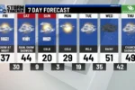
| Day | Forecast | High Temperature (°F) | Low Temperature (°F) | Wind Speed (mph) | Precipitation Chance |
|---|---|---|---|---|---|
| Today | Variably cloudy, breezy, and warmer | Low to mid 40s | N/A | 15-25 | N/A |
| Tonight | Mostly cloudy and breezy | N/A | Low 30s | 5-10 | N/A |
| Tuesday | Partly sunny to mostly cloudy | Mid 40s | N/A | 5-10 | N/A |
| Wednesday | Cloudy with a chance of rain/snow showers | Lower 40s | N/A | N/A | Chance of rain/snow |
| Thursday | Mostly cloudy | Near 40 | N/A | N/A | N/A |
| Friday | Partly sunny and mild | Low 40s | N/A | N/A | N/A |
| Saturday | Colder with scattered snow showers | Mid 30s | N/A | N/A | Chance of snow |
| Sunday | Mostly sunny, cold, and quiet | Low 30s | N/A | N/A | N/A |
Understanding the Major Melt-Down
This week, West Michigan will experience significant warming, leading to a major melt-down of the snowpack. After weeks of cold temperatures, where the mercury dipped below freezing for 16 days, the arrival of milder air is a refreshing change. Forecasts predict high temperatures reaching the low to mid 40s, making it the warmest stretch seen so far this year. As temperatures rise, many will notice the snow starting to disappear rapidly.
The transition from cold to warm weather can be surprising, especially after a long spell of winter. This weather shift will not only impact the snow but also the environment. As the snow melts, it will lead to water running into rivers and lakes, which is essential for replenishing our water sources. Additionally, this change marks the approach of meteorological spring, which begins on March 1, signaling even more changes in weather patterns ahead.
What to Expect This Week
As we look ahead, the forecast for West Michigan shows variably cloudy skies and breezy conditions. Today, you can expect highs in the low to mid 40s with southwest winds making it feel even nicer outside. Tonight, temperatures will dip into the low 30s, but remain relatively mild for this time of year. Overall, this week promises a pleasant break from the harsh winter temperatures we’ve been experiencing.
On Wednesday, the weather takes a slight turn as clouds increase and a chance of rain or snow showers comes into play. While the first half of the week will be warm, Wednesday’s cooler afternoon highs in the lower 40s remind us that winter is still holding on. However, the forecast shows no major storms ahead, allowing everyone to enjoy the warmer temperatures before the week ends with a return to colder conditions.
Preparing for Spring’s Arrival
With meteorological spring just around the corner, this is a great time for people in West Michigan to prepare for the changes ahead. The warming temperatures and melting snow can lead to the start of spring cleaning and outdoor activities. Residents can take advantage of the sunny days to check their gardens and yards, getting them ready for the growing season. It’s also a good opportunity to check for any winter damage around homes.
As the weather warms up, it’s important to stay updated on the forecast. Changes in weather can happen quickly, especially during the transition from winter to spring. The FOX 17 Weather page will provide the latest updates, helping families plan their days and outdoor activities. Enjoying the milder weather while being prepared for any surprises is key to making the most of this beautiful time of year!
Understanding the Major Melt-Down
The major melt-down occurring this week signifies a significant change in weather patterns for West Michigan. As milder air sweeps in, the snowpack that has built up from the prolonged cold will start to dissipate rapidly. This transition marks a noteworthy shift from the previous weeks, where residents endured a continuous cold spell. Understanding this melt-down is crucial as it impacts not just the local weather but also the environment, including waterways and wildlife.
Meteorologists are closely monitoring this phenomenon as it leads to an increase in temperatures, reaching the low to mid 40s. This warm stretch is a welcome change after the previous 16 days of freezing temperatures, which is notable in February’s history. The effects of this melt will be felt in various sectors including agriculture, transportation, and daily life, making it essential for residents to stay informed about the ongoing weather developments.
What to Expect This Week
As we move through the week, residents can expect varying weather conditions. Starting with mild temperatures today and tomorrow, the forecast suggests partly sunny to mostly cloudy skies. The high temperatures will provide a brief respite from winter, but as we approach mid-week, the possibility of rain and snow showers looms. This fluctuation in weather may lead to slick roads and changing travel conditions, so it’s important to stay updated.
By mid-week, the forecast predicts scattered rain showers, particularly on Wednesday. This precipitation may further contribute to the melt-down, leading to increased runoff and potential flooding in susceptible areas. Therefore, while the warmer temperatures are a welcome change, they come with challenges that require careful monitoring. Residents should keep an eye on local alerts and prepare for changing conditions as the week progresses.
The Impact of Seasonal Changes
As we transition from winter to meteorological spring, the impact of seasonal changes becomes more evident. The major melt-down not only signifies warmer temperatures but also affects the natural landscape in West Michigan. Snowmelt plays a crucial role in replenishing rivers and lakes, which is vital for the local ecosystem. Additionally, the shift in temperature can trigger early blooms in flora, indicating a change in the seasonal cycle.
However, this sudden change can also pose risks, such as potential flooding and the onset of spring allergies as vegetation begins to awaken. Residents need to prepare for these shifts by being aware of their surroundings and adjusting their routines accordingly. Understanding these seasonal impacts can help the community adapt to the changes and appreciate the beauty of nature’s cycles.


Preparing for Weather Variability
With the major melt-down and unpredictable weather patterns, it’s essential for residents to prepare effectively. Keeping an updated weather app or following local forecasts can provide timely alerts about sudden changes. Furthermore, ensuring that homes are ready for possible water runoff can prevent damage and maintain safety. Simple measures, such as clearing gutters and ensuring proper drainage, can mitigate potential flooding risks.

Additionally, being proactive about personal safety during variable weather conditions is crucial. This includes having emergency kits ready and being aware of road conditions before traveling. By staying informed and prepared, residents can navigate the unpredictability of spring weather while minimizing disruption to their daily lives. Awareness and readiness will make all the difference in adapting to these changes.
Frequently Asked Questions
What is a weather melt-down and why is it happening?
A **weather melt-down** happens when warm air causes **snow** to melt quickly. It’s happening now because milder air is moving into West Michigan after a very cold February.
How do temperatures change during a melt-down?
During a melt-down, **temperatures** rise. For example, this week, temperatures are expected to reach the **low to mid 40s**, which feels warm after many cold days.
What does it mean when we say it is a breezy day?
A **breezy day** means there are light to moderate **winds** blowing. For instance, today in West Michigan, winds are 15 to 25 mph, making it feel cooler outside.
Why is meteorological spring important?
**Meteorological spring** starts on March 1, marking the beginning of warmer weather. It’s important because it signals the end of winter and the start of blooming flowers and longer days.
What kind of weather can we expect this week?
This week, expect **partly sunny** to **cloudy** days with a chance of **rain** or **snow** on Wednesday. Highs will be in the low to mid 40s, making it milder.
What happens when temperatures drop below freezing?
When **temperatures** are below **freezing**, water turns into **ice** or **snow**. This can lead to cold, snowy weather, like what West Michigan experienced for 16 days in February.

How can I stay updated on weather changes?
To stay updated on weather changes, you can check the **FOX 17 Weather page**. They provide the latest forecasts and important weather alerts to keep everyone informed.
Summary
The content discusses the upcoming weather changes in West Michigan, highlighting a significant warm-up as milder air arrives. After a prolonged cold spell with 16 consecutive days below freezing, temperatures will rise to the low to mid 40s this week, marking the warmest period of 2025 so far. While no major storms are expected, a light rain/snow mix may affect northern areas. The forecast also indicates scattered rain showers by mid-week, with meteorological spring commencing on March 1. Overall, the update provides essential insights into the weather transition and anticipated conditions for the coming days.
